Image of a 3D animation of the largest feature mapped in the Charlie-Gibbs Fracture Zone, extending 3708m above the surrounding seabed. The shallowest depth is 979m below sea surface, with depths of 4687m recorded at the base some 20km away. Note the legend is depth rather than height. The triangle is a single slice (swathe) of multibeam data acquired from the ship on the sea surface, moving along its survey track – the white line.

Image of a 3D animation of the largest feature mapped in the Charlie-Gibbs Fracture Zone, extending 3708m above the surrounding seabed. The shallowest depth is 979m below sea surface, with depths of 4687m recorded at the base some 20km away. Note the legend is depth rather than height. The triangle is a single slice (swathe) of multibeam data acquired from the ship on the sea surface, moving along its survey track – the white line.
Photo Credit: supplied

What’s down there? Mapping the ocean floor

Canada, Ireland, and the US joint project

A multi-national ocean mapping effort was announced this week.

It’s the first effort of the Transatlantic Ocean Research Alliance, formed following the Galway Statement of 2013 on Atlantic Ocean Cooperation.

Researchers from Memorial University in Newfoundland will be participating in the Irish, Canadian, and US effort, with additional participation from Portugal.

Randy Gillespie (MSc, P.Geo) is Director of the Centre for Applied Ocean Technology at Memorial University, in the city of St John’s where I spoke to him via mobile phone.

Listen
Randy Gillespie (MSc, P.Geo) Director of the Centre for Applied Ocean Technology at Memorial University, in the city of St John’s, Newfoundland and Labrador
Randy Gillespie (MSc, P.Geo) Director of the Centre for Applied Ocean Technology at Memorial University, in the city of St John’s, Newfoundland and Labrador © Memorial

The  goals of the Transatlantic Ocean Research Alliance are to join resources of its three signatories to better understand the North Atlantic Ocean and to promote the sustainable management of its resources.

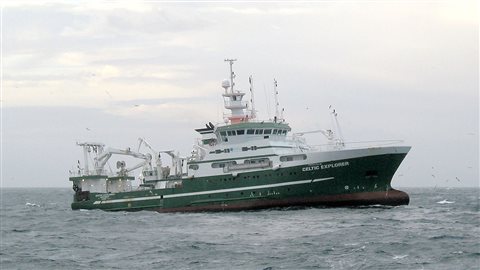
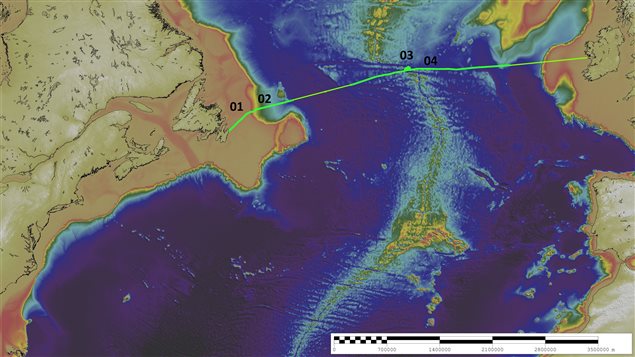
Canada’s Fisheries and Marine Institute  at Memorial University will use the Irish research vessel, RV Celtic Explorer, to map the seafloor between St. John’s, Newfoundland and Labrador, Canada and Galway, Ireland.

The provincial government has invested approximately $5 million in RV Celtic Explorer expeditions since 2010 to support fisheries science activities.

The vessel has just completed this year’s fisheries survey and is returning to Ireland providing the additional opportunity for this trans-Atlantic mapping survey.

Research Vessel Celtic Explorer which will be mapping the ocane floor from St John's
Research Vessel Celtic Explorer which will be mapping the ocane floor from St John’s © wiki commons

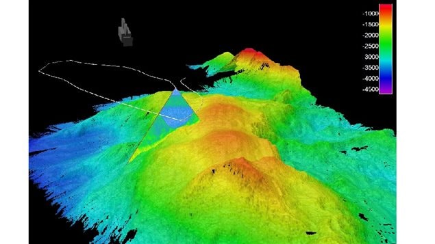
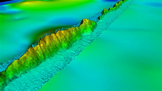
The team will gather information on the physical characteristics of the seafloor, such as depth, physical characteristics of the floor, rock, sand or mud bottom,  and the presence of geohazards, such as pinnacles, ridges, and sea mounts. This becomes useful for shipping safety issues if near subsurface structures are found, and also for development-related seabed engineering and sustainable fisheries.

The vessel mapped a 140km section of an asymmetric volcanic ridge feature at 3800m depth, associated with the Atlantic spreading. 3D perspective of the ridge, from West to East, overlain on previously available GEBCO data.
The vessel mapped a 140km section of an asymmetric volcanic ridge feature at 3800m depth, associated with the Atlantic spreading. 3D perspective of the ridge, from West to East, overlain on previously available GEBCO data. © supplied

Canada’s own research vessel, the CCGS Louis St Laurent, will be participating in another mapping effort from Canada to Oslo later this year, while in 2016 the Celtic explorer will be joined by mapping vessels from Norway and the US.

Overview of the Atlantic Transect. from StJohn's over Canada's continental shelf, the ocean's central rdige, to the Irish shelf and Galway in Ireland
Overview of the Atlantic Transect. from StJohn’s over Canada’s continental shelf, the ocean’s central rdige, to the Irish shelf and Galway in Ireland © supplied
Categories: Environment & Animal Life, International, Internet, Science & Technology, Society
Tags: , , , , , , , , , , , ,

Do you want to report an error or a typo? Click here!

For reasons beyond our control, and for an undetermined period of time, our comment section is now closed. However, our social networks remain open to your contributions.