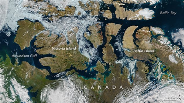
They say an image is sometimes worth a thousand words. And this NASA satellite photograph of the nearly ice free Northwest Passage snaking through the Canadian Arctic Archipelago illustrates the Arctic’s “new normal” as climate change continues to transform the region.
The famed Arctic sea route, connecting the North Atlantic and Pacific Oceans, is usually chocked full of sea ice for most of the year. But this image of the Northwest Passage captured on August 9, 2016 by NASA’s Visible Infrared Imaging Radiometer Suite (VIIRS) on the Suomi NPP satellite shows a path of open water from the Amundsen Gulf to Baffin Bay, with a scattering of broken ice just east of Victoria Island.
This is rapidly becoming the new norm even if this year doesn’t break the 2012 ice extent loss record, said Walt Meier, a sea ice scientist at NASA’s Goddard Space Flight Center in Greenbelt, Maryland.
“A decade ago, this year’s sea ice extent would have set a new record low and by a fair amount,” Meier said. “Now, we’re kind of used to these low levels of sea ice – it’s the new normal.”
(click to listen to the full interview with Walt Meier)
ListenSea ice reached a record low maximum extent in March and relatively rapid ice loss through May. The melt slowed down in June, however, making it highly unlikely that this year’s summertime sea ice minimum extent will set a new record, Meier said.
“Even when it’s likely that we won’t have a record low, the sea ice is not showing any kind of recovery. It’s still in a continued decline over the long term,” said Meier. “It’s just not going to be as extreme as other years because the weather conditions in the Arctic were not as extreme as in other years.”
NASA says this year’s sea ice cover of the Barents and Kara seas north of Russia opened up early, in April, exposing the surface ocean waters to the energy from the sun weeks ahead of schedule. By May 31, the extent of the Arctic sea ice cover was comparable to end-of-June average levels.
But the weather changed in June and slowed the sea ice loss, Meier said. A persistent area of low atmospheric pressure, accompanied by cloudiness, set in the Arctic.
“That kind of put a break on things and that was pretty persistent through most of June and July, and really has continued even into August,” Meier said.
But a really strong low pressure system, similar to one that occurred in early August 2012, moving across the Arctic now could once again accelerate sea ice melt, he said.
Four years ago, the storm caused an accelerated loss of ice during a period when the decline in sea ice is normally slowing because the sun is setting in the Arctic, Meier said.
“You know these years that now seem quite ordinary would have been extraordinary in the past,” Meier said. “The 2005, at that time was the lowest sea ice on record. It was a pretty remarkable event… Well, now 2005 is the 10th lowest in the records and after this year it would be the 11th lowest.”
The 2005 sea ice extent levels now seem completely mundane he said.
“Certainly, I would say the extraordinary years have become ordinary.”


For reasons beyond our control, and for an undetermined period of time, our comment section is now closed. However, our social networks remain open to your contributions.